
I. Executive Summary
 he U.S. Department of Energy (DOE) has indicated that transportation of nuclear waste to the proposed Yucca Mountain Nuclear Waste Repository will be conducted with a combination of rail and highway routes. Eureka County has three federal and state highways that potentially could be used for truck transport of nuclear waste to Yucca Mountain. he U.S. Department of Energy (DOE) has indicated that transportation of nuclear waste to the proposed Yucca Mountain Nuclear Waste Repository will be conducted with a combination of rail and highway routes. Eureka County has three federal and state highways that potentially could be used for truck transport of nuclear waste to Yucca Mountain.
A Union Pacific main railroad line also passes through northern Eureka County. In addition, DOE has considered the construction of a rail corridor route through Eureka County - the "Carlin Spur" - leaving the Union Pacific main line at Beowawe in Eureka County and running southwest through Crescent Valley, as an alternative for waste transport. While in 2005 the DOE selected an alignment leaving the main Union Pacific tracks at Caliente, in Lincoln County, as the only route currently to be studied for rail transportation to Yucca Mountain, there still is a possibility that the Carlin route might be used if the Caliente route proves unfeasible.
This report examines current use and operations of the three state and federal highways, and one railroad main line that passes through Eureka County, including traffic volumes, accident statistics, physical conditions, weather effects, operations, and the regulatory structure, so that potential areas of delay, hazard, and other conditions that might affect nuclear waste transport may be identified.
Union Pacific Railroad — Information about rail operations in Eureka County was obtained from the Federal Railroad Administration (FRA), the State of Nevada Public Utilities Commission, the American Association of Railroads (AAR), and published sources including the Union Pacific Corporation's website. Repeated attempts were made to directly interview a Union Pacific representative regarding rail operations in the county, but telephone calls and email massages asking for information were not returned.
Union Pacific Railroad operates dual lines through Eureka County. In the study area (from Battle Mountain in Lander County to approximately Maggie Creek in Elko County, a distance of about sixty miles), the lines follow the Humboldt River, passing through Palisade Canyon in Eureka County. The lines cross once, just east of Barth in Palisade Canyon, go through several tunnels, and cross the Humboldt River on bridges several times.
The Union Pacific dual lines through Eureka County are a part of a major corridor rated for the heaviest trains. In 2003, 27 trains per day passed through the study area, as well as two passenger trains. Principal commodities carried by Union Pacific in Nevada are coal, chemicals, aggregates, lumber and consumer goods. Rail traffic fluctuated during the 1970's and 1980's in the study area, reaching a high in 1986. While it was not possible to obtain rail traffic data for the study area for the 1990's, data obtained from the Surface Transportation Board for the Western U.S. as a whole show that during the 1990's rail ton miles throughout the West increased, so it is assumed that ton miles also increased in the study area during that time period.
There were 73 rail accidents or incidents in the study area between 1975 and 2005: total reported damage to tracks and equipment in the accidents was $7,702,901. The largest accident that took place in the study area, in terms of dollar damage, was a derailment and chemical spill near Battle Mountain in 2001.
The number of rail accidents in the study area has dropped since the early 1980's, possibly as a result of track and equipment improvements carried out after industry deregulation, combined with newly-instituted safety programs.
Forty-four percent of accidents in the study area were equipment-caused; 25% were track-caused; 24% were human-caused; 7% had miscellaneous causes. Derailments were the most common type of accidents in the study area, accounting for 81% of all accidents. Most accidents occurred on the main track, and most accidents involved freight trains.
Eleven accidents involved trains carrying hazardous materials, but there was only one hazardous spill during the 1975-2005 time period. In addition to accidents, Eureka County firefighting personnel report that rail operations may ignite wildland fires, these fires may be caused by sparks resulting from friction between the equipment and the rail.
Two potential weather effects which might affect rail operations in the study area were identified. First, extreme hot and cold weather may cause increased damage in derailment accidents, due to the expansion and contraction of rails. Temperatures within the range that may have an effect exist in the study area only at the cold extreme, not at the hot extreme. The author of the study cited in this report cautions that these results may no longer apply in light of track improvements made in recent decades.
Second, floods in the Humboldt River are the more serious weather effect in the study area. Flooding caused at least one of the major accidents during the time period. In addition, a 1910 flood washed away the tracks entirely. Photographs taken in May 2005, when the Humboldt River was flowing at about 2000 cubic feet per second (cfs) above flood stage, show water standing on or around the tracks. (See Photo Below - More photos are presented in Appendix E) 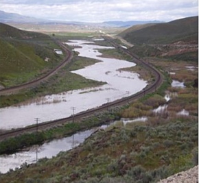
On the dual Union Pacific tracks through the study area, train movement is controlled by an Automatic Block Signal (ABS) system in which the railroad is divided into sections known as blocks. A train cannot enter a block until it is permitted, generally by a signal that the block ahead is empty, or by warrant from the train dispatcher.
Union Pacific operates trains in accordance with a code of operating procedures and timetables supplemented by special instructions. General operating procedures are laid out in federal regulations implemented by the Federal Railroad Administration (FRA), but each railroad has its own code which may include additional practices.
In a July, 2005 policy statement the DOE announced a decision to use dedicated trains to transport SNF and HLW to the proposed Yucca Mountain nuclear waste repository. AAR (American Association of Railroads) and DOE say that these dedicated trains are the safest way to ship the waste, but some questions about the use of dedicated train remain, including whether waste shipment will be solely by dedicated trains or by a mix of dedicated and general trains.
Railroads are responsible for regular inspection of all track, equipment and operations. Each railroad must make written schedules of inspections, as well as inspection results, available to the FRA. The FRA and the Nevada Public Utilities Commission (PUCN) also conduct regular inspections, but these inspections function more as oversight for the railroad's own inspection program.
Standards and procedures for transporting hazardous materials are laid out in federal regulations; railroads implement the hazardous materials management in their codes of operating procedures. Hazardous materials inspections are again carried out by the PUCN and the FRA. Responsibility for response to hazardous spills is shared by the railroad, the federal government, state agencies and local government.
Union Pacific has an emergency management plan to guide emergency response; emergency procedures also are in the timetables carried by each train crew. The closest Union Pacific emergency response crews to the study area are located in Roseville, California and Salt Lake City, Utah.
The railroads themselves are responsible for security of railroad operations, property and cargo, unlike the aviation industry, where the federal government provides security personnel. Union Pacific has increased security in several ways since the 9/11 terrorist atttack.
Recommendations for Further Study or Follow-up: Rail —
It is possible for Local Emergency Planning Committees (LEPC) to obtain information on the flow of hazardous materials through their communities by submitting a request for such information on a form provided by the railroad (see Appendix F for a generic copy of this form from the American Association of Railroads.) This information, if regularly obtained by Eureka County's LEPC, would not only supplement this report, but help in the County's hazardous response planning efforts.
Additionally, it is recommended that the Eureka County LEPC obtain information from Union Pacific on the railroad's emergency management plan and emergency management procedures that apply to the Eureka County area. This would also aid the County in emergency and hazardous waste incident response planning efforts.
Roadway Assessment — Our assessment of the three study roadways concluded that the three state routes have different traits as follows.
 I-80 — Interstate 80 has traffic volumes of about 6,500 daily vehicles through Eureka County with approximately 32% of them being trucks. Traffic has increased over the past 10 years by 2% per year. The closest annual speed monitoring station (Wendover) shows the average speed on I-80 to be approximately 75 mph and the 85th percentile (design speed) to be approximately 83 mph. The speed limit on I-80 is 75mph. I-80 — Interstate 80 has traffic volumes of about 6,500 daily vehicles through Eureka County with approximately 32% of them being trucks. Traffic has increased over the past 10 years by 2% per year. The closest annual speed monitoring station (Wendover) shows the average speed on I-80 to be approximately 75 mph and the 85th percentile (design speed) to be approximately 83 mph. The speed limit on I-80 is 75mph.
There were 577 accidents reported in Eureka Count on I-80 since 1994, with 25 fatalities. There were 21 work-zone accidents reported with 15 injuries and three fatalities. A major work-zone accident occurring in the early 2000's was revealed during the interview process but was not included in the work-zone accident data provided by NDOT. The majority of the accidents along I-80 through Eureka County occurred in the Emigrant Pass area with nearly double the accidents compared to other segments of I-80. The top three most common accident causes over the past 10 years were "speed too fast for conditions," "inattentive driving" and "animal in roadway".
I -80, and specifically Emigrant Pass, receives top priority for snow removal and maintenance compared to other State routes within Eureka County. According to NDOT, seasonal snow, fog, wind, ash, and dust are the major weather events that affect travel along I-80. Other events not detailed in accident reports include brush fires from stalled vehicles or accidents along I-80, and trucks using alternate routes through Eureka County when I-80 is closed getting stuck or losing their load on inadequate routes.
Numerous NDOT encroachment permits for overhead and underground utilities exist along I-80 consisting mainly of phone, fiber optic, and power. Other utilities such as natural gas lines and fuel lines may exist outside of NDOT right-of-way.
Four bridge structures along I-80 near Dunphy are on the State's "structurally deficient" list. The Sufficiency Rating of these structures suggests that they can be rehabilitated in order to bring them up to sufficient standards. Three other bridges near Dunphy, not directly on I-80, are also structurally deficient. These bridges are on US 40, but could potentially disrupt nuclear waste transport by rail or road and possibly contaminate the Humboldt River if an incident occurred on these bridges.
SR 278 — SR 278 serves as a north/south connector through Eureka County. Traffic volumes have increased by about three percent (3%) per year on SR 278 near Carlin and Eureka (650 daily vehicles). Traffic between Carlin and Eureka has remained relatively constant at about 350 vehicles per day. NDOT reports estimate that 12.9% of the vehicles on SR 278 are trucks. Passing is allowed 85% of the length of SR 278.
One hundred and sixty-five accidents were reported in Eureka County on SR 278 since 1994, with two fatalities. There were three work-zone accidents reported with one injury and no fatalities. The top three causes of accidents on SR 278 over the past ten years are; "animals in the roadway," "inattentive driving," and "speed too fast for conditions." Existing speed data along SR 278 does not exist or was not made available from NDOT. Weather effects documented along SR 278 from interviews with NDOT or County staff including Mormon cricket infestations, blowing snow, and floods. SR 278 has secondary priority in snow removal and other maintenance.
One bridge on SR 278 is on the State's structurally deficient list (B-478). This bridge is within the rehabilitation category but is expected to soon qualify for complete replacement. The County airport has access from SR 278 approximately 3.5 miles north of US 50.
US 50 —
This route extends from I-5 in Sacramento, through Nevada, to I-215 in Utah. In Eureka County, US 50 has seen nearly no growth in traffic over the past 10 years, with average annual daily traffic volumes at under 2,000. According to NDOT, an estimated 19.6% of those vehicles are trucks. Within Eureka County passing is allowed approximately 92.5% along the length of US 50. Speeds on US 50 near Eureka are shown to be approximately 70 mph, with an 85th percentile speed of approximately 78 mph. Speed limits in the same area are 70 mph.
The top three causes of accidents on US 50 over the past ten years are "animals in the roadway", "inattentive driving," and "speed too fast for conditions." There were 208 accidents reported in Eureka Count on US 50 since 1994, with nine fatalities. There were four work-zone accidents reported with one injury and no fatalities.
Major weather occurrences on US 50 consist mainly of winter snow storms, drifting snow and flash floods. US 50 has secondary priority in snow removal and other maintenance unless recurring flooding or other events increases maintenance priorities.
|