|
Part 4: ANTICIPATED
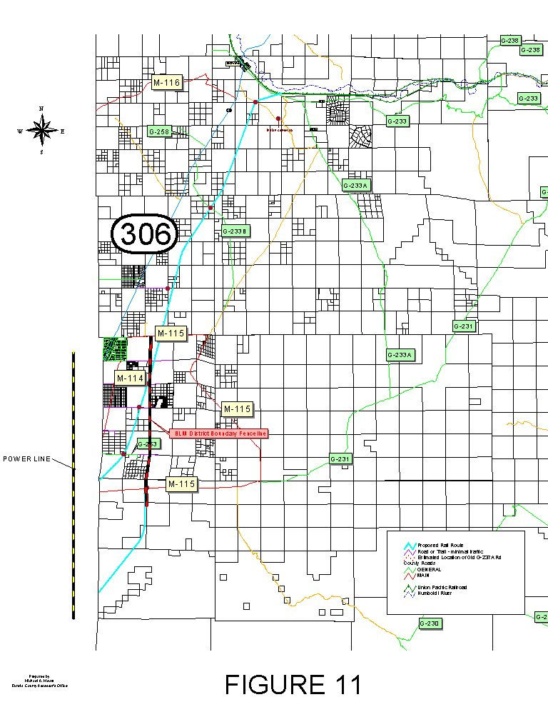
IMPACTS OF THE PROPOSED ACTION IN EUREKA COUNTY, NEVADA A. The Natural Environment Environmental impacts, generally A complete assessment of the impacts of the proposed action, particularly the rail line, is not possible until the DOE provides more detailed information on construction and operations. (Moore, 2001b) The DEIS for the proposed geologic repository (USDOE, 1999a, p. 2-49) says: Construction activities would include the development of construction support areas; construction of access roads to the rail line initiation points and to major structures to be built, such as bridges; and movement of equipment to the construction initiation points. The number and location of construction initiation points would be based on such variables as the route selected, the length of the line, the construction schedule, the number of contractors used for construction, the number of structures to be built, and the locations of existing access roads adjacent to the rail line. The assessment of impacts performed by the DOE (1999a) was limited mainly to anticipated impacts within a set distance of the identified rail corridors. However, railroad yards, borrow areas, areas for disposal of surplus fill, staging areas, access roads to construction initiation points, and other construction activities will result in impacts outside the identified corridors. Such activities are poorly defined, and will occur where no environmental baseline data have been collected (Moore, 2001b). The remainder of this part of the impact assessment report addresses the anticipated impacts of “accident-free” transportation of spent nuclear fuel (SNF) and high-level radioactive waste (HLW), as well as the impacts of a transportation accident. In this context, “accident” means a transportation incident in which a SNF or HLW shipping cask hits the ground, either by rolling off a truck or rail car, or by the truck or rail car overturning. “Severe accident” means a transportation incident in which a damaged shipping cask releases radioactivity into the environment. Hydrology and water resources Impacts of accident-free rail transportation. Where the corridor crosses the area of the 100-year flood, as mapped by FEMA (1998), the Carlin railroad spur would be vulnerable to damage and or inundation for approximately eight miles or more between Beowawe and the Town of Crescent Valley, and also to the southeast of the town along Thomas Creek. Construction of the rail spur and access roads may change the boundaries of flood areas, subjecting new properties to flooding, flood damage, and higher insurance costs. This impact would be most prevalent on the upgradient side of the proposed alignment or other flow obstruction. (See flood plain map, Figure 2.) The DOE says (1999a) that a storm or runoff event greater than the 100-year storm may wash out access roads or the rail line, and that operations would stop during potential flooding conditions or during repairs. (The DOE assumes, apparently, that shippers of SNF and HLW can anticipate floods and adjust accordingly.) A flood-related disruption of the shipping campaign would expose workers and County residents to radioactivity from parked or stalled shipments, or from any legal-weight trucks that take the place of rail cars during an extended period of flood damage repair. Surface water contaminants that would probably be released during the construction phase include petroleum products (fuel and lubricants) and coolants (antifreeze), and there is a potential for releases from storage at work camps, supply trucks, and removal trucks (USDOE, 1999a). Potential releases during rail line construction also include waste oils and grease, PCBs, releases from vessel cleanouts, empty and crushed drums, sanitary wastes, drilling fluids and muds, solid wastes, construction wastes, and tires. Whether these contaminants would reach surface waters depends on the location of their release; certainly the Humboldt River and all streams and springs in the vicinity of construction activities would potentially be affected. (Contaminants spilled on the ground would eventually reach groundwater or surface water, unless they became bound to soil particles. Certain contaminants, such as solvents, are very mobile in most soils.) To the extent that water wells are installed during the construction phase, withdrawals of groundwater could affect flows in nearby streams and springs, including the Humboldt River. The DOE (1999a) identifies these additional impacts of the Carlin rail spur: changes in the infiltration rate; introduction of new sources of contamination; and depletion of groundwater from increased demand. Any waste rock piles that are created by the proposed action have the potential for acid rock drainage (ARD) and associated effects on water resources. To avoid impacts, the waste rock should be evaluated with acid-base accounting, and the acid generating potential (AGP) of waste rock should be monitored during excavation and disposal. Because the Crescent Valley receives an annual average of less than ten inches of precipitation, the amount of water available to cause ARD is low. (See USDOI, 1999.) Until additional information becomes available regarding the construction of the proposed rail line, specifically regarding cuts, fills, and borrow areas and the reclamation plans for such areas, it is assumed that they will also have surface water impacts in addition to those impacts already discussed in these paragraphs. Impacts of accident-free truck transportation. Accident-free transportation of SNF and HLW through Eureka County by legal-weight truck would create a potential impact on water resources from the release of water pollutants in truck emissions during routine operations. If such transportation required the construction of facilities, that construction would also create a potential impact on water resources from soil erosion during construction and the release of contaminants during construction and operation. Impacts of a transportation accident. A transportation accident involving shipments of SNF and HLW through Eureka County would have a large potential impact on water resources. In an accident with no discharge of radioactivity, there would still be a risk of fuel spills, as well as damage to water resources from personnel and equipment responding to the accident. All accidents would also create a risk of wildfire, which would also have potential impacts on water resources. In a severe accident with a release of radioactivity, there would be a possibility of a profound impact on the Humboldt River or the aquifer of the Crescent Valley, with long-term and widespread effects. Air resources Impacts of accident-free rail transportation. During the construction phase of the proposed action, the combustion of diesel fuel in haul trucks and mobile equipment (such as loaders and bulldozers), along with any combustion of propane and fuel oil, would create elevated ambient levels of carbon monoxide, particulate matter, oxides of nitrogen, and sulfur dioxide in the air. Combustion emissions from construction equipment are relatively uncontrolled at the exhaust pipe. (See USDOI, 1999.) The DOE says (1999a) that construction of the branch rail line could temporarily increase pollutant concentrations due to fuel use by construction equipment and fugitive dust from excavation and truck traffic. Construction of the rail line would also result in the loss of soil through wind erosion, with associated air quality impacts (Moore, 2001b). For the air quality analysis of Cortez Gold Mines’ South Pipeline Project (in USDOI, 1999), the following sensitive air quality receptors were identified: Filippini Ranch, Tenabo Ranch, Wintle Ranch, Dean Ranch, Dann Ranch, Crescent Valley School, Beowawe School, and the Jarbidge Wilderness. Presumably, these same receptors would be affected by air pollution from the proposed action, as would the Crescent Valley Clinic and other locations. During the operations phase of the proposed action, vehicle emissions from train locomotives, employees’ personal vehicles, and other vehicles would constitute additional sources of air pollutants, including carbon monoxide, oxides of nitrogen, sulfur dioxide, particulate matter, and other constituents of gasoline and diesel fuel exhausts. According to the DOE (1999a), the construction of the proposed action would comply with all applicable air quality regulations. Nevertheless, the proposed action would diminish existing air quality, and reduce visual range in Eureka County and downwind areas by adding particulate matter and other light-scattering or light-absorbing pollutants to the air. At this time, Eureka County does not know how the proposed action would be affected by the prevention of significant deterioration (PSD) requirements of the federal Clean Air Act. If the construction or expansion of a large stationary source of air pollution triggered the PSD requirements in the Crescent Valley Air Basin, the proposed action could, in effect, compete with other sources for authority to discharge particulate matter or other pollutants. Such a scenario could cause problems for existing industries, and complicate economic development. Impacts of accident-free truck transportation. During shipments of SNF and HLW through Eureka County by legal-weight truck, engine exhaust gases from the trucks would constitute an additional source of air pollutants, including carbon monoxide, oxides of nitrogen, sulfur dioxide, particulate matter, and other constituents of diesel fuel exhausts. Impacts of a transportation accident. A severe accident involving the release of radioactivity from a shipment of SNF or HLW in Eureka County has a potential for creating a catastrophic air pollution episode, probably of short duration, but resulting in fatalities or other serious human health effects. Depending upon its location, such an episode could affect a large number of persons and animals downwind from the accident. All accidents, regardless of severity, also create risks of air pollution from fire, wildfire, land disturbance resulting in wind erosion, and other factors. Vegetation and soils Impacts of accident-free rail transportation. The proposed action would result in the disturbance of as much as 1,000 acres of vegetation and soils in Eureka County, including the railroad bed, access roads, work camps, the Beowawe facilities, and other areas. The flat cross-sections of the rail corridor largely eliminate the need for cuts, but create a significant demand for borrow material to construct the road bed. Construction of the road bed in Eureka County would require 1.6 million cubic yards of fill material in excess of that generated by required cuts. Based on the DOE’s assumptions that borrow material will be obtained from adjoining areas and that those areas will be excavated to a depth of 20 feet, more than 49 acres of borrow area will be required in the County (Moore, 2001b). The depth to groundwater in much of the Crescent Valley is 15 to 20 feet. Since fill material must not be saturated with water, excavation of borrow pits below the water table is unlikely. Therefore, the probable result is an even greater area of surface disturbance in order to obtain required fill. In addition, the DOE would probably be required to construct a landfill for solid waste generated during construction of the rail line, and this requirement would again increase the amount of land disturbed by the project (Moore, 2001b). It is not known at this time whether, and to what extent, the proposed action would affect identified sensitive plant species. In terms of vegetation generally, the proposed action would normally result in a conversion from a shrub-dominated community to a community of grasses and other low-growing plants in the short term. Once established, shrub species would become dominant in three to five years, but 15 to 20 years would be required to establish mature shrubs. The reclaimed plant community would be expected to stabilize the construction site and to provide forage for wildlife and livestock in the short term. However, the extensive proposed land disturbance would produce habitat conducive to invasion by noxious weeds, and vehicles used during both construction and operations would help spread weed seeds. Weed species rapidly invade disturbed areas, and initially hinder establishment of more desirable perennial plants, by outcompeting them for moisture. Noxious weeds are typically very aggressive, and have the ability to dominate sites, creating dramatic impacts to native plants and decreasing forage for livestock and wildlife. (See USDOI, 1999.) According to BLM policies, a project is considered to have a significant effect on noxious weed management if it results in: (1) an increased likelihood of noxious weed species being introduced into a relatively weed-free area at moderate or high ecological risk, or (2) an expansion of noxious weed infestation inside and outside the project area into relatively weed-free areas a high or moderate risk. (See USDOI, 1999.) Construction of the proposed rail line would also result in a loss of soil through wind erosion (Moore, 2001b) and water erosion, as well as a loss of infiltration capacity through compaction. Impacts of accident-free truck transportation. The transport of SNF and HLW through Eureka County by legal-weight truck would create a potential impact on vegetation from the spread of noxious weeds, since motor vehicles are one means by which noxious weed seeds are spread. Impacts of a transportation accident. An accident involving a shipment of SNF or HLW through Eureka County would also increase the risk of spreading noxious weeds, due to the operations of emergency vehicles and personnel, and also the creation of newly disturbed soils, which are vulnerable to weed invasions. Such an accident also would create a risk of wildfire, with associated impacts upon vegetation and soils. A severe accident involving a release of radioactivity would create a need to remove contaminated soils, possibly in large quantities, as well as a risk of soil disturbance during the emergency response period. These impacts, in turn, would create a risk of soil erosion and the spread of noxious weeds. Wildlife and fish Impacts of accident-free rail transportation. In general, impacts to fish and wildlife of the construction and operation of the proposed rail corridor would result from the removal of wildlife habitat, structural modification to wildlife habitat, and noise. (See USDOI, 1999.) Also, without undisturbed access to critical habitat, wildlife may abandon large areas of year-round habitat. Loss of wildlife habitat is not limited to physical loss due to rail line construction. Operation of the rail line would reduce the value of habitat crossed by, or near to, the line. Human activity (such as operating trains) in or near critical habitat can seriously degrade the value of that habitat for wildlife, especially for linear facilities that pass through habitat areas (Moore, 2001b). Throughout the Crescent Valley, any fencing of the right-of-way would adversely affect the movement of pronghorn antelope. Linear facilities, such as a rail line, affect pronghorn by blocking their migration paths, particularly when rights-of-way are fenced. Pronghorn rarely jump a fence, but rather go under fences. Therefore, the type of fencing used would be critical to pronghorn, and at least 18 inches of clearance above the ground is recommended (Moore, 2001b). As the proposed rail corridor crosses the Toiyabe Range at Dry Canyon Summit, it would, if fenced, create an impediment to the movement of mule deer, as well as a danger of entrapment (McKenzie, pers. comm., 2001). Year-round deer habitat in the vicinity of Beowawe may suffer similar impacts. Although the proposed rail line would not cross the sage grouse strutting ground located southeast of Beowawe, it would be close enough that construction and operation of the rail line would adversely affect the use of the strutting ground. Also, the strutting ground lies within an area that could be used for facilities required at the interconnection point with the UPRR (Moore, 2001b). It is not known at this time whether, and to what extent, the proposed action would affect other sensitive species of wildlife. According to the DOE (1999a), construction activities in areas designated as game habitat by the BLM and NDOW would result in loss of habitat, and construction of the rail line could lead to habitat loss and fragmentation for special status species, as well as individual mortality. Such impacts would constitute a take under the federal Endangered Species Act. The DOE says (1999a) that fences, where constructed, will accommodate movement of game animals. Elsewhere in the same document, the DOE says that fences would not be likely to affect the movement of mule deer and elk, but may impede movement of antelope, mountain sheep, horses, and burros, and may divide management areas for these species. The potential impacts on water resources, described earlier, may have adverse effects on brook trout and brown trout residing in streams in the Crescent Valley area. Impacts of accident-free truck transportation. Shipments of SNF and HLW through Eureka County by legal-weight truck would create potential impacts on fish and wildlife through the release of environmental contaminants in motor vehicle exhausts, the possible spread of noxious weeds, and wildlife mortality resulting from collisions with trucks and escort vehicles. Impacts of a transportation accident. An accident involving a shipment of SNF or HLW through Eureka County would create a potential impact on fish and wildlife from loss of habitat, through wildfire, ground disturbance, contamination, or a combination. The loss of habitat could be temporary or, in the case of severe accident, permanent. In a severe accident involving the release of radioactivity, direct mortality could occur to birds or fish in the immediate vicinity. Range resources Impacts of rail transportation. Construction of the railroad bed, access roads, cuts, and fills would destroy forage used by cattle and other animals. For the railroad bed itself, the width of disturbance would be about 200 feet during construction and, due to possible problems with reclamation and invasion by noxious weeds, 200 feet should be considered the width of long-term disturbance. If the railroad bed right-of-way is not fenced, individual animals would hesitate or refuse to cross the tracks, and the management of livestock would be complicated by herding problems and interference with such operations as salting and facility maintenance. A reduction in available AUMs of 0.1 percent is assumed, to reflect the effect on management, unless special circumstances exist in a specific allotment or field (McKenzie, 2001). If the railroad bed right-of-way is fenced, the fencing could reduce or prevent access to important sources of stock water, which would reduce or eliminate the usefulness of a portion of an allotment. Fencing could also isolate an area of grazing land, making it unusable by the present operator, and causing additional reductions in available AUMs (McKenzie, 2001). For purposes of this report, a fenced construction and buffer area 400 feet wide is assumed. Railroads typically use box culverts to provide underpasses for movement of livestock and equipment under their tracks. Possible locations for these underpasses are highly dependent on terrain, since the required height can often be provided by natural drainage ways. However, the level terrain of the Crescent Valley suggests there will be little or no opportunity for this use of box culverts (Moore, 2001b). Members of the public in the Crescent Valley have reported problems with damage to fences by the actions of public and private parties. Construction of the proposed rail line would clearly cause damage to existing fences, which may or may not be repaired by the project proponent. Specifically regarding the Geyser allotment (see Figure 7), Zeda, Inc., would be the only operator affected by the proposed action, under present arrangements. The railroad bed would run about 13 miles south from the north boundary of the allotment, at the UPRR, to a point about 1.5 miles east of the Town of Crescent Valley, where it would leave the allotment. Forage production is low on most of the land directly affected. If the ROW were unfenced, forage would be destroyed or become unavailable on about 317 acres. The reduction in available AUM would be about 0.4 percent or 13 AUM, due to the loss of forage and interference with operations. If the ROW were fenced, forage would be destroyed or become unavailable on about 633 acres. The reduction in available AUM would be about 10.6 percent or 331 AUM, due to the loss of forage, the isolation of the eastern third of the allotment, and loss of access to water sources (McKenzie, 2001; Moore, 2001b). Regarding the South Buckhorn allotment (see Figure 7), the railroad bed would enter the allotment in the Native Pasture about 1.5 miles east of the Town of Crescent Valley. The primary alignment would pass through the east fence into Gravel Pasture, then exit the pasture, the allotment, and the County about five miles south of the Town. The alternative alignment would pass through the south fence into the Dean Pasture, and exit the pasture, allotment, and County about 10 miles south of the Town (McKenzie, 2001). If the primary alignment were selected and the ROW unfenced, forage would be destroyed or become unavailable on about 44 acres in the Native Pasture and 119 acres in the Gravel Pasture. The resulting reduction in AUMs in the South Buckhorn alllotment would be about 0.02 percent (5 AUM) on the Native Pasture and 2.4 percent (2 AUM) on the Gravel Pasture, due to construction impacts, isolation of water sources, and interference with operations. If the ROW were fenced, the reduction in available AUM would be about 81 AUM, due to splitting the Gravel Pasture into two fields, one without water (McKenzie, 2001; Moore, 2001b). If the alternative alignment were selected and the ROW unfenced, forage would be destroyed or become unavailable on about 163 acres in the Native Pasture and 119 acres in the Dean Fenced Federal Pasture. The resulting reduction in AUMs in the South Buckhorn allotment would be about 0.09 percent (20 AUM) on the Native Pasture and 1.1 percent (5 AUM) in Dean Fenced Federal Pasture, due to the loss of forage from construction. If the ROW were fenced, forage would be destroyed or become unavailable on about 327 acres in the Native Pasture and 238 acres in the Dean Fenced Federal Pasture. The reduction in available AUM would be about 0.16 percent or 41 AUM in Native Pasture and 12.1 percent (54 AUM) in Dean Fenced Federal Pasture, due to the loss of forage plus splitting the Dean pasture into two fields, both with water (McKenzie, 2001; Moore, 2001b). Impacts of accident-free truck transportation. The shipping of SNF and HLW through Eureka County by legal-weight truck would create possible impacts on range resources from the release of pollutants in vehicle exhausts, the possible spreading of noxious weeds, and collisions between livestock and trucks or escort vehicles. Impacts of a transportation accident. An accident involving a shipment of SNF or HLW through Eureka County would create a potential impact on range resources from loss of forage, through wildfire, ground disturbance, contamination, or a combination. The loss of forage could be temporary or, in the case of severe accident, more or less permanent. In a severe accident involving the release of radioactivity, direct mortality or serious injury could occur to livestock in the immediate vicinity. Scenic resources Impacts of accident-free rail transportation. To the extent that the proposed action affects existing landscapes that viewers travel through, recreate in, or reside in, there would be an effect on scenic quality. It is likely that the proposed rail line, and the various facilities near Beowawe, would affect views of and views from the Maiden's grave, which is a widely-appreciated viewpoint among persons familiar with the area. One assessment of visual impacts could be based on the BLM’s visual contrast rating system, in which effects on visual resources would be assessed for construction, operation, and closure of the proposed action. Two issues would be addressed: (1) the type and extent of actual physical contrast, and (2) the level of visibility of the facility, activity, or structures. (See USDOI, 1999.) In the BLM’s impact rating system, visual effects are evaluated by identifying line-of-sight points of project visibility, as well as key observation points (KOP), from which proposed facilities may be visible from routinely accessible vantage points. The extent of the impacts of the proposed action would depend upon the amount of visual contrast created between the proposed facilities and existing landscape elements (i.e., form, line, color, texture) and features (i.e., land and water surfaces, vegetation, structures). (See USDOI, 1999.) Under the BLM’s impact rating system, impacts are significant if visual contrasts resulting from a proposed action affect: (1) the quality of scenic resources, especially those with rare or unique values, or (2) views from, or visual settings of, designated or planned parks; wilderness and natural areas; other visually sensitive land uses; travel routes; recreational, educational, and scientific facilities; use areas and activities; and viewpoints or vistas. (See USDOI, 1999.) According to the DOE (1999a), the proposed action would not exceed the aesthetic criteria in the BLM’s visual resources management guidelines, but more stringent management requirements would be necessary to maintain the existing character of the landscape if the rail line crossed Class II lands. (The Crescent Valley is classified as Class IV.) Impacts of accident-free truck transportation. If the shipment of SNF and HLW through Eureka County required the construction of maintenance or service facilities, such facilities would have a potential impact on scenic resources, by affecting views and contrast ratings. Impacts of a transportation accident. An accident involving a shipment of SNF or HLW through Eureka County would have potential scenic impacts associated with the risk of ground disturbance or wildfire. A severe accident involving a major contamination episode could have a profound scenic impact, depending upon its location. If, for example, the accident were adjacent to the Humboldt River, the appearance of the River corridor could suffer long-term degradation during decontamination efforts. B. The Human Environment Cultural resources Impacts on cultural resources, generally. Regardless of the alternative selected, the proposed action would irreversibly alter a historic way of life in the rural West. The oral history project, Eureka Memories, listed in the introduction to this report, documents this aspect of cultural resources. Impacts of accident-free rail transportation. Ground disturbance activities during the construction phase of the proposed rail corridor could crush or disturb archeological sites, or expose or cover sites by creating soil erosion. Indirect impacts may also occur during the construction phase, including disturbance of archeological sites by purposeful or accidental actions of project employees (USDOE, 1999a). Possible impacts could also occur during both construction and operations to sacred springs and burial sites of the Newe (i.e., Western Shoshone), and to Pleistocene fossils. (See USDOI, 1999.) Other cultural resources that would be potentially impacted are the Maiden’s Grave (which is about one mile from the proposed connection to the UPRR tracks near Beowawe), Gravelly Ford, the California trail, the Pony Express Trail, and other historic roads and trails. Impacts of accident-free truck transportation. If the shipment of SNF and HLW through Eureka County by legal-weight truck required the construction of service or maintenance facilities, the proposed action would have a potential impact on cultural resources, due to ground disturbance or direct damage to the resources. Such shipments, whether they occur in Eureka County or elsewhere, could also result in an economic slowdown or fiscal impacts on governmental entities, with resulting indirect impacts on cultural resources (from lack of maintenance and upkeep, for example). Impacts of a transportation accident. An accident involving a shipment of SNF or HLW through Eureka County would have potential impacts on cultural resources related to damage occurring during emergency response and the risk of wildfire, both of which could cause trampling, crushing, or exposure of cultural items. Such impacts may be greater in the vicinity of the Humboldt River. In the event of a severe accident with a release of radioactivity, access to cultural resources would be potentially lost due to contamination, and the resulting economic slowdown would create indirect impacts on cultural resources. Population and demographics Impacts of accident-free rail transportation. The DOE (1999a) says that the Carlin rail line would result in a statewide population increase of 790 persons. It is not known how much population growth, if any, would occur within Eureka County. After the completion of the construction phase, the new operational jobs associated with the rail line would probably result in some employees and their families residing in Eureka County. (However, the Beowawe facilities would also be within driving distance of residential areas in Battle Mountain and Elko County.) Operation of the rail line as a shared facility would also create the potential for new jobs and some new County residents. Any economic downturn would cancel some or all of the gains. Impacts of accident-free truck transportation. The shipment of SNF and HLW through Eureka County by legal-weight truck would create a possible small increase in employment for service and maintenance personnel or businesses, with a resulting small increase in population. Whether the shipments passed through Eureka County or not, however, economic impacts could cancel some or all of the gains. Impacts of a transportation accident. In the event of an accident involving a shipment of SNF or HLW through Eureka County, the resulting economic downturn would result in employment and population losses in the County. It is possible that those remaining in the County would be the least mobile or adaptable persons, including the elderly and the poor. In a severe accident involving a release of radioactivity, there would be a risk of direct and indirect mortality to the population. Land ownership Impacts of accident-free rail transportation. The construction of the proposed Carlin rail line through Eureka County would convert a large, but presently unknown, amount of private land to public use, by willing-seller transactions, the use of eminent domain, or sale under threat of eminent domain. Note that 60 percent of the assessed private parcels of land in Eureka County are within 10 miles of the proposed tracks. The conversion of private land to public use would have secondary impacts on economics and property tax revenues, and would conflict with Eureka County’s master plan, which encourages the conversion of public land to private ownership. (See Figure 9, map of land ownership as affected by the corridor.) Impacts of accident-free truck transportation. If facilities are required to support the shipment of SNF and HLW through Eureka County by legal-weight truck, there would be a small potential impact on land ownership, from the conversion of private land to public use, or the conversion of public land to a different public use. Impacts of a transportation accident. An accident involving a shipment of SNF or HLW through Eureka County would result in County-wide devaluations of private property, especially in the immediate vicinity of the accident, but land ownership would remain the same, at least initially. It is possible that such an accident would force distress sales of private property, to public entities or to other private parties. Economy Generally. The presence of any industrial facility or operation in a given area will create direct and indirect economic impacts. Unlike some non-nuclear facilities, however, nuclear facilities involve such issues as fear and perceived risk. In one example, the Clinch River MRS facility, an environmental study group identified potential adverse impacts for business recruitment and expansion, residential recruitment and retention, institutional trust, tourism, aesthetics, and neighbors (DOE, 1999a). Thus, these less tangible types of impacts must be considered, in addition to direct impacts on employment and spending, for example. Similarly, the State of Nevada has raised concerns regarding negative perceptions of nuclear waste, including possible reductions in short-term visitation, in-migration, and the ability to attract new businesses. Economic impacts could, therefore, include reduced economic activity and the loss of income and jobs as a result of the decline of visitors to the area and the decline of property values along waste transportation routes. Reasons for diminished property values include fear, risk, and stigma for the residential sector. In the commercial and industrial sectors, reasons include worker fear, higher insurance premiums, loss of prestige locations, product tainting, and loss of productivity during accident scenarios. (Massey, pers. comm., 2001) Impacts of accident-free rail transportation. Development of the Carlin rail line will affect the economy of Eureka County due to construction and annual operation of the line. Two types of economic impact are generally associated with industrial development projects that require large capital outlays. First, the construction phase requires an influx of workers from outside the area, and increases economic activity and the amount of money circulating in the local economy. Materials and services may be purchased locally, for example. Second, the post-construction phase requires a considerably smaller labor force, which can lead to a boom and bust cycle and downsizing costs. During the operations (post-construction) phase, the labor force and population base are more stable, and private sector investment occurs in retail trade and services, based on market conditions (Fletcher, 2001). Economic sectors that could be affected by construction and operation of the rail line include: mining, government, tourism, recreation, agriculture, and main-street business (Fletcher, 2001). During the construction phase, Fletcher (2001) assumes that work camps will provide food and lodging, that all available housing will be promptly occupied, that temporary housing may be imported, and that local economic activity will increase from retail purchases of food, beverages, groceries, gasoline, and miscellaneous items. There would be a small stimulus to the local economy while work crews were in the vicinity, but it would be unlikely to create additional investment. (If additional investment is small, the likelihood of an economic bust upon departure of the crews would be minimized.) The DOE (1999a) says that construction would result in 500 direct-employment construction jobs for three years, and that there would be 47 operations jobs. The DOE also says that the Carlin rail line would result in 1,100 new jobs. Economically speaking, an important aspect of the proposed action is the construction and operation of rail headquarters facilities near Beowawe, which would have a permanent economic effect (Fletcher, 2001). These facilities would be staffed with permanent employees, likely from outside Eureka County, and create increased demand for housing, schools, and government services. It is likely, also, that the private sector would respond with retail and service establishments, based on supply and demand projections. There are a number of uncertainties regarding the economic impacts of these facilities near Beowawe, including: (1) the exact location of the operations headquarters and maintenance facilities, (2) their size and staffing requirements, (3) their timing, (4) their effect on visitation, and (5) whether the rail line would be a single-use or shared-use line. The facilities could become the nucleus of expanded economic development, planned or unplanned, along the I-80 corridor, including industrial enterprises, housing, and utilities (Fletcher, 2001). One economic effect related to development of the Carlin rail line is the loss of livestock production, measured in AUM, as discussed earlier in this part. These economic effects are a function of the total AUM available, livestock access to forage, the number and location of livestock underpasses, and the availability of stock water. Based on a University of Nevada Cooperative Extension fact sheet, the average value of an AUM is $28.16 (Fletcher, 2001). Thus, the loss of 100 AUM (e.g., 20 cows for 5 months) would have a value of $2,816. Every loss of 100 AUM would translate into a decrease of $5,365 in total annual economic activity in Eureka County, including $1,218 in annual personal income, and the loss of 0.07 jobs. (See Fletcher, 2001.) Fletcher (pers. comm., 2001) advises against converting these static estimates of economic impact into long-term estimates, given the many unknowns that affect long-range forecasts. Nevertheless, the present value of the economic activity associated with a decrease of 100 AUM, each year for 100 years, with an interest rate of 4 percent, is about $131,500 (calculation by the editor). Another economic impact of development of the Carlin rail line would be impacts on tourism and visitation. Fletcher (2001) estimates that Eureka County receives about 20,758 overnight visitors per year. Each visitor-night contributes $89.93 in total economic activity, including $23.37 in personal income, to the local economy, and supports 0.0018 jobs in Eureka County. Although the effect of the presence of the rail line on visitation is unknown, it is unlikely to increase visitation, given the issues of fear and perceived risk. If annual visitation decreased by 10 percent (i.e., by 2,076 visitor-nights per year), Eureka County’s economy would suffer a loss of $186,695 in total economic activity, including $48,516 in personal income, and four jobs. (The present value of the economic activity associated with a 10 percent decrease in visitor-nights, each year for 38 years of a shipping campaign, with an interest rate of 4 percent, is about $3.62 million (calculation by the editor).) One particular category of visitation to Eureka County is hunting and fishing. If development of the rail line decreases visitation and expenditure associated with hunting and fishing, economic impacts will be created (Fletcher, 2001). In Nevada, the average angler spends nine days per year fishing, spending $37 per day. The average hunter spends 13 days per year hunting, spending $32 per day. Wildlife viewing is another popular activity; the average participant spends $585 per year on this activity. (USDOI & USDOC, 1998). In addition, economic impacts on private property owners with improvements in close proximity to the rail line can be expected. Some property owners may be adversely affected, depending on their ingress and egress and the number and location of accessible crossings (Fletcher, 2001). Based on a review of a separate analysis prepared for the State of Nevada regarding Clark County (UER, 2000), Eureka County’s assessor estimates that property values within three miles of the rail corridor and the UPRR tracks would be adversely affected by three percent (Fletcher, 2001). Thus, the net value of property in Eureka County within three miles of the UPRR tracks and the proposed spur would decrease from $8,893,521 to $8,626,715 (Mears, pers. comm., 2001). In the absence of an accident, the diminution of property values would occur with the commencement of shipping of SNF and HLW, and continue throughout the shipping period. If shared use of the rail line were to occur, the affected area would experience increased economic productivity from increased transportation opportunities, lower transportation costs, reduced accidents, and lower air pollution emissions than comparable shipment by truck, according to the DOE (1999a). Rail transportation may be a cost-effective option for such activities as exporting containerized alfalfa hay, importing feed grains and other concentrates for use in dairy production, and other possible uses (Fletcher, 2001). Impacts of accident-free truck transportation. The shipment of SNF and HLW through Eureka County by legal-weight truck would involve little or no construction, and a smaller operations effort than rail transportation. Nevertheless, economic impacts would result from fear and perceived risk issues, including property devaluation, loss of tourism and visitation, and loss of retail business. There would be a potential small economic impact from retail sales to truck crews and escorts. Impacts of a transportation accident. A severe accident involving the release of radioactivity in Eureka County would have a large impact on the County’s economy (Fletcher, 2001). The extent of the impact would be a function of prevailing winds and the perception of potential harm. The extent of the impact would not be a direct function of the length of the rail right-of-way in Eureka County or the severity of the accident. The impact on property values would be large, depending on their proximity to the accident. There would be adverse impacts on property sales, investment, lending, and financing (Fletcher, 2001). Extrapolating from the study of Clark County (UER, 2000), an accident without the release of radioactivity would significantly decrease property values (in the range of one to eight percent, depending on the use of the property and its proximity to the accident), and an accident with the release of radioactivity would result in a much larger loss of property value (from ten to 34 percent, again depending on use and proximity). Eureka County estimates that the net value of private property within three miles of the existing UPRR tracks and the proposed Carlin spur would decrease, in the event of an accident with a release of radioactivity, from $8,893,521 to $6,047,594 (32 percent) (Mears, pers. comm., 2001). Also, to the extent an accident causes a reduction in available AUMs, or a decrease in visitation to the County, the same types of economic effects described earlier (for accident-free rail transportation) would also occur. Housing Impacts of accident-free rail transportation. During construction of the proposed Carlin rail line, all available housing units in Eureka County (or at least the northern portion) would be immediately occupied, and additional housing would likely be provided in response to housing demand, either temporarily or permanently, in addition to the housing provided at work camps. During the operations phase of the proposed rail line, housing impacts would depend on the number of jobs created and the percentage of those employees choosing to live in Eureka County. Shared use of the rail line would likely result in more new jobs and a higher demand for housing. However, any economic slowdown resulting from loss of visitation, loss of livestock production, or other factors would offset some or all of the increased housing demand. Impacts of accident-free truck transportation. The shipment of SNF and HLW through Eureka County by legal-weight truck would create a slight additional demand for housing for service and maintenance employees. Again, however, any economic slowdown would offset some or all of the increased demand. Impacts of a transportation accident. An accident involving a shipment of SNF or HLW through Eureka County would result in a potential increase in housing vacancy rates from the associated economic downturn. A potential deterioration of housing stock would also occur, from lack of maintenance and investment. The extent of these impacts would be proportional to the perceived seriousness of the accident. A severe accident, or a fire resulting from an accident, could also cause the actual physical loss of housing stock, temporarily or permanently. Mining and minerals Impacts of accident-free rail transportation. If shared use of the proposed rail line were to occur, mine owners and operators would potentially benefit from lower transportation costs for supplies and their production. On the other hand, construction of the rail line would potentially result in the withdrawal of mineral lands or outright taking or purchase of mining claims or patents near or adjacent to the right of way. (See Figure 10, map of patented mining claims.) The rail line and its effects on local roads would also cause possible access issues for mines and miners. According to testimony before the DOE at the Crescent Valley public hearing on December 9, 1999, the proposed rail line would divide the existing Cortez mine (in Lander County) and cross a haul road that is in regular use. Impacts of accident-free truck transportation. Regular or irregular shipments of SNF and HLW through Eureka County by legal-weight truck would create potential operational conflicts for mining, resulting from shared use of highways by trucks carrying hazardous mining materials (e.g., explosives) and trucks carrying SNF and HLW shipments. Impacts of a transportation accident. An accident involving a shipment of SNF or HLW through Eureka County would create potential access problems for mines and miners, if access points had to be closed off as a result of contamination, temporarily or permanently. An accident may also diminish the supply of available laborers for the mines, due to worker fear or perceived risk of radiation. Infrastructure and public facilities Impacts of accident-free rail transportation. The construction phase of the proposed rail line would generate a significant volume of liquid and solid wastes, including waste lubricants, solvents, paint, other hazardous materials, sanitary wastes, industrial wastes, and scrap rails, ties, bridge timbers, and track fastenings (USDOE, 1999a; Moore, 2001b). Also, construction of proposed support facilities, such as those proposed at Beowawe, would generate waste concrete, lumber, packaging, and other wastes. To the extent that these wastes are not salvaged and must be disposed of within Eureka County, they would constitute an additional burden on the County. Construction wastes may not be compatible with waste handling facilities at existing sites, and the volume of waste may consume all available capacity in the Eureka landfill, to which northern Eureka County exports its solid waste (Moore, 2001b; A. Johnson, pers. comm, 2001.). Regarding aviation, the proposed rail line would be located about 700 yards east of the Town of Crescent Valley’s airport. Based on the slope of the ground to the east, regulations of the Federal Aviation Administration for this class of airport require that potential obstructions (such as the rail line) be at least 500 feet from the end of the runway. Construction of the rail line as proposed would, therefore, prevent any future lengthening of the affected runway or any change in the level of service it provides (Moore, 2001b). Also, the proposed rail line would bisect several local roads in Eureka County. (See Figure 11 for a map of affected roads.) A person’s ability to cross the rail line would greatly influence the Map of roads in the Crescent Valley, as affected by rail line construction degree of the impact on that person. As described earlier in this report, the DOE plans one grade-separated road crossing in Eureka County, for the intersection of the proposed rail line with the Dean/Dann/Spa Road, County Road M-115. The DOE also plans one signaled at-grade crossing at an unspecified location. The remaining crossings would be unsignaled, at grade. Given the lack of topographic relief, the use of underpasses would be very limited (Moore, 2001b). The proposed action would cause significant delays at at-grade crossings of the Beowawe-Rose Ranch Road (County Road G-233) near Beowawe. Delays at this location would occur because of its close proximity to the connection with the existing UPRR tracks and the interchange with mainline trains. The impacts would be greater if the DOE selects the general freight option, since rail cars carrying SNF and HLW would have to be switched out of freight trains and stored at a siding for delivery to the proposed geologic repository via the Carlin spur. With dedicated trains, delays would be shorter (Moore, 2001b). Delays at the at-grade crossing of County Road G-233 would degrade emergency services provided by the Beowawe Volunteer Fire Department. When the crossing is blocked, response calls to the east of Beowawe on G-233 would be delayed. Responding units would either have to wait for the tracks to clear or travel north on I-80 and south on County Roads G-236 and G-238 to respond (Moore, 2001b). Although G-233 is lightly traveled at the present time, development in the vicinity of Beowawe and the Humboldt River corridor could increase traffic volumes. County Road G-233B, Cold Springs Point Road, would also be affected by construction and operation of the proposed rail line where the two intersect. Current school bus routes would not be affected by the proposed rail line. (One current route generally follows Nevada 306, connecting the Town of Crescent Valley with Beowawe and Battle Mountain. Another route connects the Crescent Valley, Pine Valley, and Carlin. It starts east of the proposed rail line at the Hay Ranch and proceeds northeast to Pine Valley and Carlin.) However, although current school bus routes would not cross the proposed rail line, some school children might need to cross the tracks to meet the school bus. Further, a rail line dividing the Crescent Valley would limit the school district’s future flexibility regarding changes in enrollment areas for elementary school students (Moore, 2001b and pers. comm., 2001). Impacts of accident-free truck transportation. Shipping SNF and HLW through Eureka County by legal-weight truck would contribute to wear and tear on the State highway system and increase the need for highway maintenance. Such shipping would also utilize some portion of the existing highway capacity, which is, in general, constrained by the factors such as those noted by Halstead (2001), including sharp curves, steep grades, passes affected by weather, two-lane configuration, lack of guard rails, and others. To the extent that shipments by truck share the highways with school buses, the shipping campaign would cause potential conflicts with parents, teachers, and school officials. Impacts of a transportation accident. An accident involving a shipment of SNF or HLW through Eureka County would have large potential impacts on infrastructure and public facilities. There would be a risk of damage to or contamination of roads, highways, schools, public buildings, equipment (especially fire-fighting and emergency response equipment), the Crescent Valley water system, and the Crescent Valley airport. Such damage or contamination could result from a non-radioactive spill, a release of radioactivity, a fire, emergency response activities, or a combination. An accident with a release of radioactivity would possibly create quantities of contaminated solid and liquid wastes, which would require appropriate disposal. Public finance Impacts of accident-free rail transportation. Construction and operation of the Carlin rail line would expose local governments in Eureka County to potential fiscal impacts, due to the need to increase government services (Fletcher, 2001) and other factors. Categories of fiscal impacts include: (1) costs incurred for emergency management and response capabilities, (2) general government and administrative costs, other than emergency management and response, (3) losses in State services due to reallocation of resources at the State level, (4) losses in visitor-related tax revenues, and (5) losses in property tax revenues. It is important to note that the Eureka County School District, the Town of Eureka, the Town of Crescent Valley, and any special districts would experience fiscal impacts, in addition to Eureka County itself. In the post-construction phase, local governments in Eureka County will have better information and a more stable tax base, and would be able to make necessary public services available. Nevertheless, there would be a need to maintain equity between established residents and new residents. It might be appropriate to consider the imposition of impact fees, by ordinance, to support capital costs of schools, utilities, streets, and parks (Fletcher, 2001). Whether a transportation accident involving SNF and HLW occurs, Eureka County would establish a regional emergency response strike force and training program, staffed by professional (not volunteer) personnel. A spreadsheet model developed for this impact assessment report (Johnson and Massey, 2001) includes costs over 40 years for personnel, communications equipment, other equipment, and training. The total of all expenditures would be $4.37 million, with a present value of $754,000 (assuming a 5 percent interest rate), to be borne by the project proponents. Regarding taxes and fees collected at the State and county levels (described earlier under the Affected Environment), the proposed action would result in a statewide economic downturn, according to the Clark County study. Therefore, the proposed action would result in lower than normal revenues to Eureka County’s local governments. The downturn would affect Eureka County regardless of what transportation alternative the DOE selects. If the Carlin rail alternative were selected, impacts on Eureka County would be magnified. Revenues would be diminished from all sources of public revenue listed in the description of the affected environment, earlier in this report. Impacts of accident-free truck transportation. The impacts on public finances from shipping SNF and HLW through Eureka County by truck would be similar to the impacts from shipping by rail. There would also be additional impacts on public finance related to wear and tear on roads and highways and the possible need to expand highway capacity. Impacts of a transportation accident. The impacts on public finances from an accident involving a shipment of SNF and HLW through Eureka County would be similar to the impacts of the accident-free scenarios, but larger in magnitude. The cost burden on the County would potentially be far greater than the County’s ability to pay, and the revenue losses could be severe. It is not known whether the County would have any exposure to liability from the short-term or long-term consequences of an accident. In any event, the County would have legal expenses resulting from any accident of this nature. Outdoor recreation Impacts of accident-free rail transportation. During both the construction and operations phases of the proposed rail line, the proposed action could limit public access to recreation areas currently in use by the public (USDOE, 1999a). Alternatively, roads constructed as a part of the proposed action could provide motorized access to allow hunters and other persons to reach new areas (McKenzie, pers. comm., 2001). If, as discussed earlier, operation of the proposed action causes a decrease in visitation to Eureka County, recreation sites would be adversely affected to the extent they are fee-supported, or receive revenue based on visitor counts. Impacts of accident-free truck transportation. The shipment of SNF and HLW through Eureka County by legal-weight truck would create a potential for impacts on outdoor recreation caused by the introduction of pollutants, the spread of noxious weeds, and effects on wildlife (especially big game). Any economic slowdown associated with such shipments, whether or not they travel through Eureka County, would also affect the supply and maintenance of developed recreation facilities. Impacts of a transportation accident. A transportation accident involving a shipment of SNF or HLW through Eureka County would create access limitations, either temporary or permanent, for nearby outdoor recreation areas. Public health and safety Generally. The health and safety of various groups of individuals would be affected by their proximity to the transportation routes. Such groups include: (1) members of the public along the route, (2) members of the public sharing the route, (3) members of the public during stops, (4) transportation and security workers, and (5) construction workers. Some health and safety issues are related to radiation, while others are not. A medical clinic serves the Town of Crescent Valley and the surrounding region; there are no medical facilities in Beowawe. In incident-free transportation, the shipping casks for SNF and HLW would still emit radiation. The amount of radiation a person would absorb depends on their distance from a cask. The DOE (1999a) estimates that radiation doses at a distance of 2 meters from the sides of the vehicles would be over half the regulatory limit. A person would absorb 10 millirem/hour at 2 meters from the side of the vehicle, and 0.2 millirem/hour at a distance of 30 meters. The DOE (1999a) has produced a very confusing array of tables of anticipated health impacts on workers and the public. The following paragraphs attempt to summarize the most salient points. Impacts of accident-free rail transportation. Exposure to radiation, in the absence of an accident, would cause 0.26 to 0.33 latent cancer fatalities (LCF) in transportation workers, and 0.31 to 0.36 LCF among the public, in the DOE’s mostly-rail scenario over a 38-year shipping campaign, statewide. Other industrial accidents from the operation of the proposed Carlin rail line would result in 210 recordable accidents and illnesses to workers, 120 lost workday cases, 0.4 worker fatalities from operations, and 1.1 traffic fatalities during commuting. A specific class of rail transportation workers, inspectors, would absorb more radiation than other workers. The DOE (1999a) says inspectors in the mostly-rail scenario would have a six percent greater likelihood of a fatal cancer than the average person (based on a 24-year shipping campaign). If administrative controls similar to those at other DOE facilities were put in place to limit the exposure of workers, including inspectors, individual doses would be limited to 2 rem per year (USDOE 1999a). If rail cars transporting SNF or HLW were delivered to Beowawe by general freight, public health would be affected by the parking of rail cars at Beowawe while trains bound for Yucca Mountain were made up. Halstead (pers. comm., 2001) has estimated the radiation doses from a shipping cask on a rail car parked at a siding. He assumes that 521 loaded rail casks would pass through Beowawe each year for 38 years under the mostly-rail scenario. A person located 20 meters (about 60 feet) from the side of a cask for a 48-hour period would absorb a radiation dose of 12 millirem. If a rail cask were parked at Beowawe 50 percent of the time, a person located 20 meters away would absorb an annual dose of 1,090 millirem, and a person located 100 meters (about 300 feet) away would absorb about 33 millirem. These levels of exposure would represent a significant increase above background radiation doses. Imus (1995) says that the background dose from cosmic and terrestrial sources is about 100 millirem per year. Other estimates of background radiation absorbed annually by individuals are in the 350 to 400 millirem range. Regarding construction workers, the DOE (1999a) estimates there will be 100 construction worker injuries and illnesses on the Carlin rail line. Impacts of accident-free truck transportation. The DOE (1999a) estimates that accident-free transportation of SNF and HLW through Nevada in the mostly legal-weight truck scenario would result in 1.2 latent cancer fatalities among workers, and 2.6 LCF among the public, over a 38-year shipping campaign, statewide. According to Halstead (2001), in towns in Nevada where buildings are located within 10 meters of shipment routes, some individuals could absorb annual doses of radiation equivalent to 40 to 60 percent of the average annual background radiation dose. The impacts of such doses are not exactly understood, Halstead says, but would impose significant socioeconomic impacts on individuals and communities. A specific class of truck transportation workers, inspectors, would absorb more radiation than other workers. The DOE (1999a) says that inspectors in the mostly-legal weight truck scenario would have a eight percent greater likelihood of a fatal cancer than the average person (based on a 24-year shipping campaign). Impacts of a transportation accident. A severe transportation accident would involve a release of radioactive material, as described earlier in this document in the description of the proposed action. The DOE (1999a) says that an individual absorbing the maximum amount of radiation from a severe accident on the Carlin rail line would absorb a dose of 26 rem. This is far higher than the maximum recommended dose for a person who works near radiation sources, and could produce very serious effects (Harvey, 1969). The DOE says that the maximum foreseeable accident scenario on the Carlin rail line would result in 31 latent cancer fatalities among the population, and that the maximally-exposed individual would have a probability of 13 thousandths of becoming a latent cancer fatality. Rural highway routes in Nevada are disadvantageous, from a safety standpoint, due to their two-lane configurations, sharp curves, steep grades, narrow shoulders, absence of guardrails, mountain passes affected by weather, and tactical concerns related to sabotage and terrorism (Halstead, 2001). The DOE (1999a) says the impacts from an act of sabotage against a legal-weight truck would be greater than the impacts from sabotage against a rail car. Although the rail car would carry six times more spent fuel, an accident involving a truck would release more radioactivity. Wind speed and direction are key variables in estimating the severity of an accident with a release of radioactivity. More information is needed on wind speed and direction in Eureka County. Noise, land use, and the quality of life Impacts of accident-free rail transportation. During the construction phase of the proposed rail line, estimated noise levels are 62 to 74 dBA within 150 meters of construction noise sources, and 54 to 67 dBA at a distance of 600 meters. Noise sources will exist both in the proposed corridor and on connecting roads to borrow and spoil areas (USDOE, 1999a). The DOE does not say whether these are cumulative or single-event noise levels. During the operations phase of the proposed rail line, assuming train speeds do not exceed 80 km/hr (about 47 mph), the estimated volume of noise from a train consisting of two locomotives and ten cars is 51 dBA at 2000 meters and 62 dBA at 200 meters, expressed as an equivalent continuous (average) sound level. The proposed rail line would be located farther from Beowawe than the existing UPRR tracks, and would carry less train traffic. Therefore, although the proposed action will increase noise levels, the increase will not be as large as the existing noise levels (Moore, 2001b). The Town of Crescent Valley is located about 18 miles from the existing UPRR tracks, while the proposed rail line would pass about one mile east of the town. This change will generally affect the nature of this rural community, and will expose the community to a noticeable increase in ambient noise levels (Moore, 2001b). Assuming a 2.5-year construction phase, construction delivery vehicles will travel 19 million miles, resulting in 0.3 traffic fatalities and 0.0014 fatalities due to vehicle emissions. Vehicles of commuting workers will travel 76 million miles, resulting in 0.8 traffic fatalities and 0.0055 fatalities due to vehicle emissions (USDOE, 1999a). During the operations phase, vehicles of commuting workers will travel 68 million miles (over 24 years), resulting in 0.7 traffic fatalities and 0.005 fatalities due to vehicle emissions (USDOE, 1999a). Note that these estimates also cover Lincoln County and Nye County. After construction of the rail line and associated structures is complete, their presence may influence future development, land use, and zoning adjacent to the rail line in the Crescent Valley or near Beowawe (USDOE, 1999a). Depressed property values (discussed earlier in this document) and uncertain economic conditions complicate predictions of the nature of such effects. It should be noted that the proposed rail line would cross areas of potential future community growth. The rail line and interchange facilities would prevent any future growth of Beowawe to the east, and the rail line would prevent any growth of the Town of Crescent Valley to the east (Moore, 2001b). Any evaluation of land use impacts should also consider the effect of dividing the Crescent Valley itself and current and future land uses with a rail line for the transport of SNF and HLW. The movement of vehicles, equipment, and livestock would be complicated by the need to cross the rail line. Splitting a ranching operation would have impacts on the entire operation, not just the area within the right of way. Similar impacts would be felt by other types of businesses, and also by governmental entities (Moore, 2001b). Impacts of accident-free truck transportation. The shipment of SNF and HLW through Eureka County by legal-weight truck would affect the quality of life for residents of and visitors to the County by introducing additional noise and traffic. There would also be possible land use effects related to an increased number of service business and facilities, as well as a potential economic slowdown related to fear and perceived risk. Overall, the quality of life would be adversely affected by the combined, mostly minor, impacts on the economy, recreation, public finance, and natural resources. Impacts of a transportation accident. The impacts upon the quality of life of an accident involving a shipment of SNF or HLW through Eureka County would be extensive, and would result from such combined factors as: diminished public health, increased health care and medical costs, an economic slowdown, image problems, demands on public finances, natural resource damage, litigation, damage to infrastructure (including water systems), contamination, loss of trained labor force, housing deterioration and lack of maintenance, declining property values, fear and perceived risk, and loss of peace and quiet and the small town way of life. |
|