Natural Resources
Natural resources are an important element of the Eureka County economy and the quality of life enjoyed by local residence. Natural resources support many critical economic sectors, provide for community development, enhance the quality of life by supporting recreational activities enjoyed by local residents and visitors. One of the most important natural resources in the County is water. In the arid west, water is precious and limited.
Water Resources — Throughout the region, precipitation varies widely between seasons and years as well as within elevation. Annual precipitation ranges from 11 to 13 inches and results mostly from winter storms although summer thunderstorms can produce large amounts of precipitation as rain but contributes little to annual precipitation. Higher amounts of precipitation generally occur as elevation increases. Above 6,000 feet it is not uncommon for areas in central Nevada to receive 14 inches of precipitation or more.
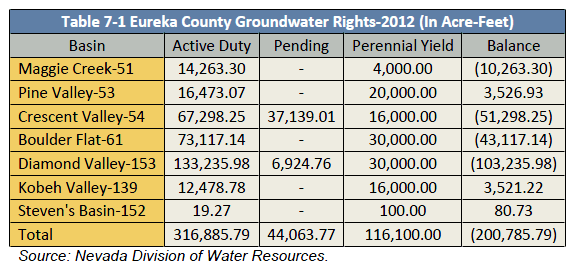
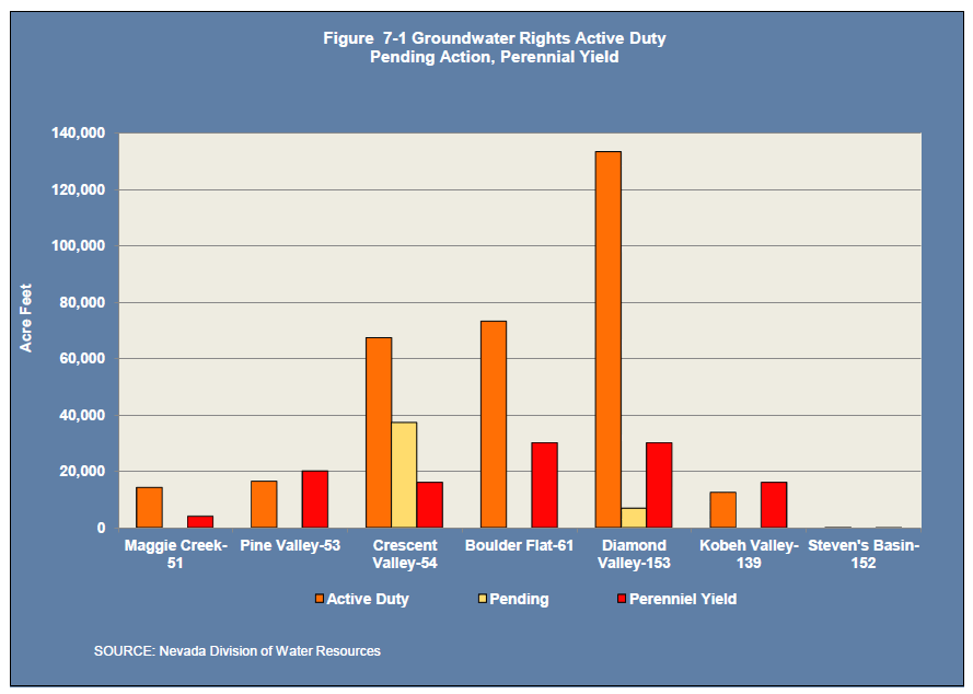
Precipitation supports groundwater recharge. Table 7-1 above shows major groundwater hydrographic basins in Eureka County including the active duty groundwater rights and perennial yield of each basin.
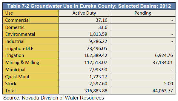
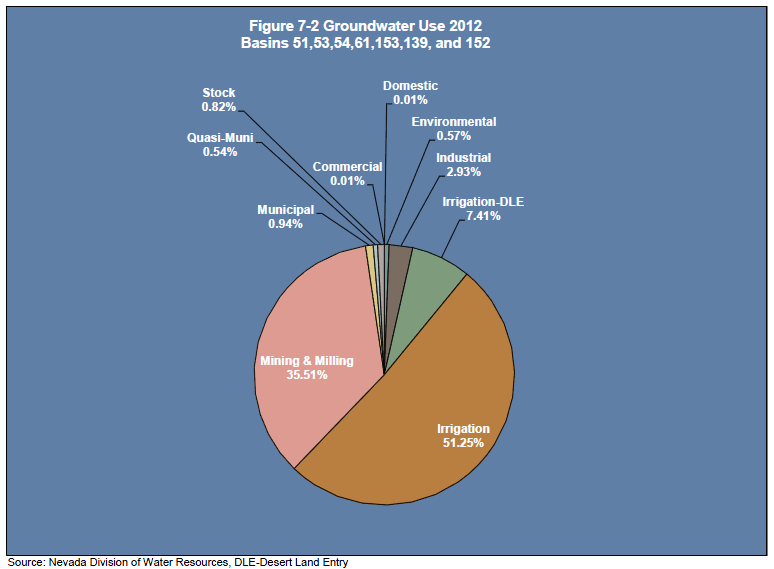
Figure 7-1 provides a comparison of active duty water rights, perennial yield and pending actions by the State Engineer. A distinctive feature is the groundwater basins where active duty groundwater rights exceed the perennial yield. Diamond Valley is one of the more extreme cases in Eureka County. Table 7-2 to the right and below shows groundwater rights by type of use in Eureka County hydrographic basins. As shown in Figure 7-2 , agriculture followed by mining and milling account for about 95 percent of groundwater right usage in Eureka County.
 Groundwater Wells and Groundwater Depth —
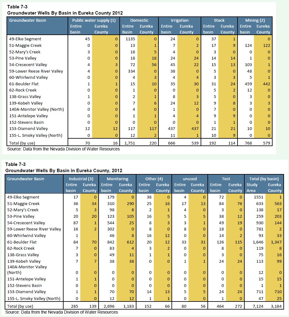
Table 7-3 shows the number of estimated groundwater wells by type of well in each basin. There are nearly 3,200 wells in the Eureka County. The largest category of wells is irrigation and mining. The total number of domestic wells is 220. Groundwater in Eureka County also supports municipal and domestic water demands. There are three municipal systems operated by Eureka County. One is located in the Town of Eureka, another in Devils Gate, and a third in the Town of Crescent Valley.
Groundwater Wells and Groundwater Depth —
Table 7-3 shows the number of estimated groundwater wells by type of well in each basin. There are nearly 3,200 wells in the Eureka County. The largest category of wells is irrigation and mining. The total number of domestic wells is 220. Groundwater in Eureka County also supports municipal and domestic water demands. There are three municipal systems operated by Eureka County. One is located in the Town of Eureka, another in Devils Gate, and a third in the Town of Crescent Valley.
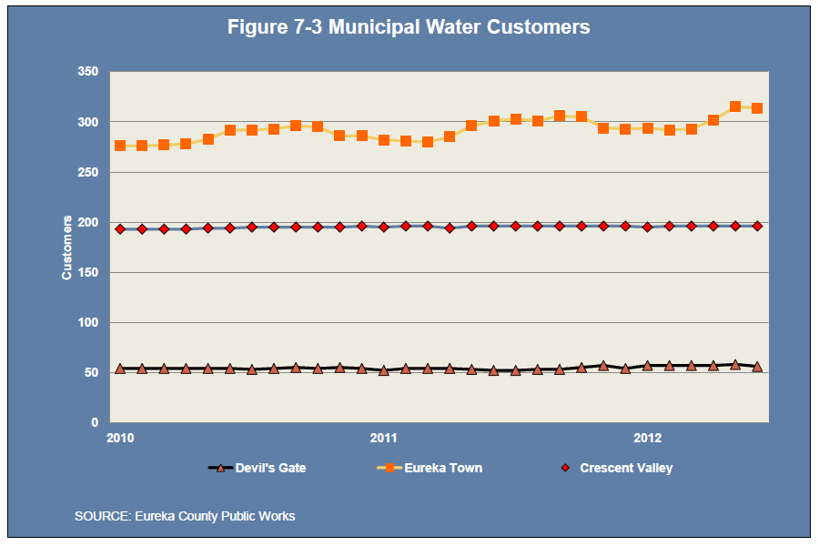
The water systems in Eureka County currently meet all drinking water standards. Arsenic treatment was recently added to the Town of Crescent Valley water system. Overall, the systems in Eureka County are in excellent condition meeting all municipal operating standards. Figure 7-3 shows the number of water customers in each system. Since 2010, there has been limited growth in the number of municipal customers served by the systems, although the Town of Eureka is trending higher.
Historic Water-Level Changes —
Water levels in the Diamond Valley Flow system have changed over time as a result of withdrawals for irrigation, municipal, domestic, and mining uses and as a result of annual long-term variations in precipitation. Most withdrawals have been for irrigation in southern Diamond Valley where the irrigated area expanded from 3,200 acres in 1961 to 22,200 acres in 1990. Water level declines from the 1960s to 2005 in southern Diamond Valley ranged from 26 to 90 feet at 67 wells. The large area of water-level decline that has been developed in the basin-fill aquifer of southern Diamond Valley underlies an area about 10 miles wide and 20 miles long.
Long-term water level records are available for only a few wells in Kobeh, Monitor, and Antelope Valleys. Kobeh Valley water levels ranged from 35-46 feet below the land surface with minor annual fluctuations generally 2-4 feet. In Monitor Valley water levels ranged from 48 to 56 feet below the land surface with limited annual fluctuations and response to short-term changes in precipitation. In northern Antelope Valley water levels ranged from 94 to 98 feet below the land surface with annual fluctuations of less than 1 foot (USGS Scientific Investigations Report 2006-5249).
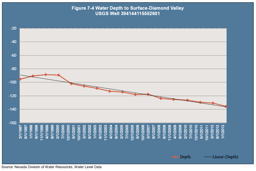
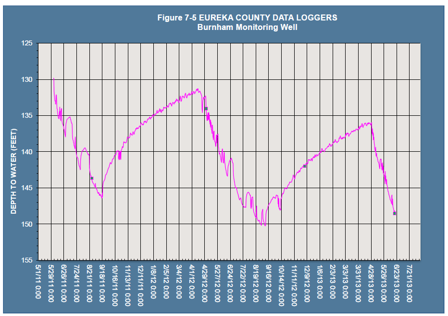
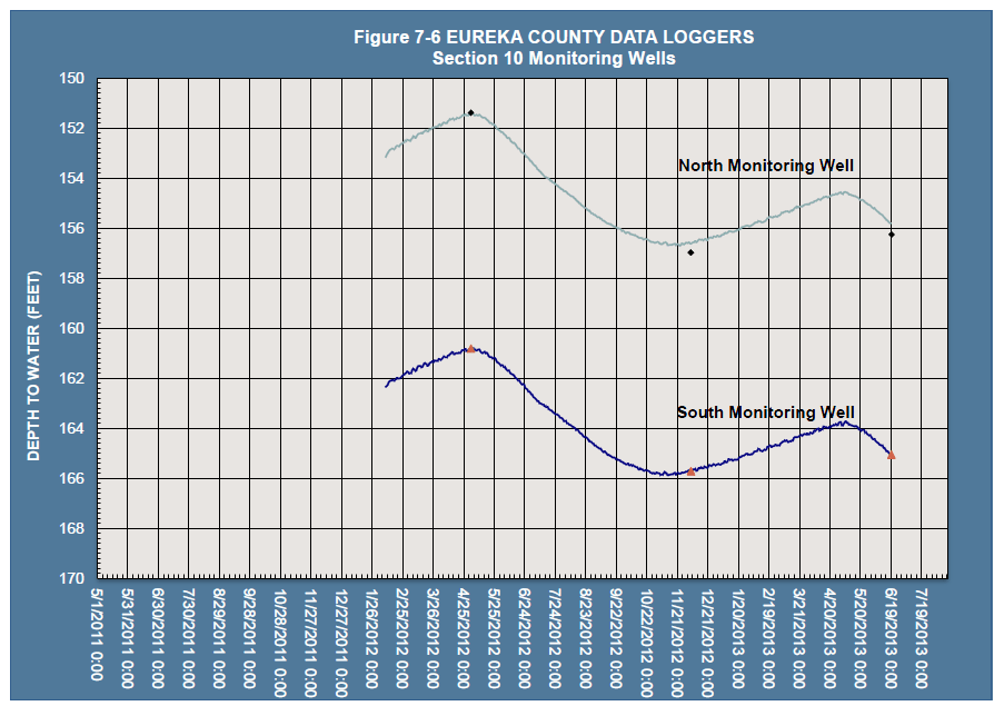
Figure 7-4 shows changes in depth of groundwater since 1997 for a USGS monitoring well in Diamond Valley. Overall declines of about 45 feet have occurred since 1997. This trend is consistent with a number of wells in the area. Figure 7-5 and Figure 7-6 shows recent trends in wells being measured by Eureka County.
Surface Water —
The major surface water feature in Eureka County is the Humboldt River which has an average annual discharge of approximately 218,000 acre-feet. Other major surface water features include Pine Creek and a series of smaller perennial streams originating in the Roberts Mountains, the Diamond Mountains, Cortez Range, and Monitor Range.
Stream flow readings are limited in Eureka County. In recent years the United States Geologic Survey installed gauging stations at streams in the Roberts Mountains. The graphs located here show real-time daily readings for Roberts Creek, Henderson Creek, Pete Hanson Creek, Tonkin Springs and Colis Creek through July 2013. Drought conditions over the last 2 winters have reduced stream flows.
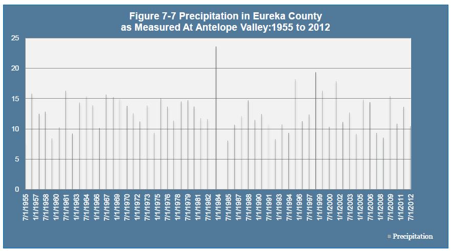
Precipitation — Precipitation in Eureka County (Antelope Valley) is shown in Figure 7-7. The average annual precipitation as measured at Antelope Valley between 1955 and 2012 is 12.74 inches. The wettest ten year period was 1980 to 1990 followed by 1990 to 2000 averaging 13.1 and 12.8 inches respectively.
Recreation —
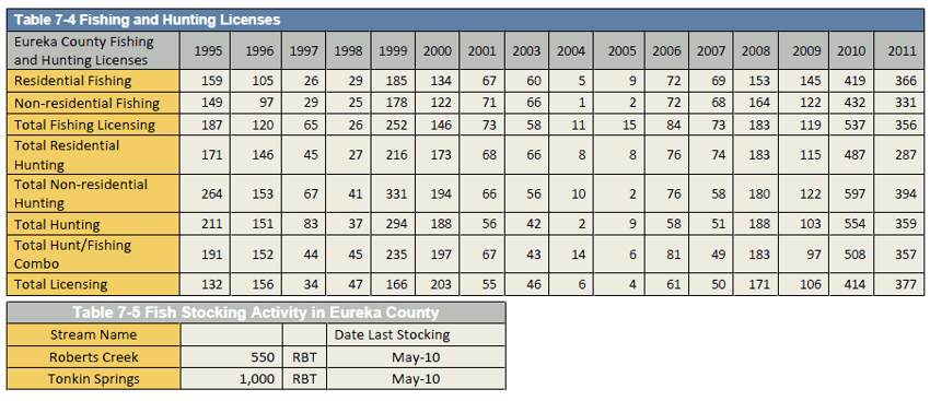
A variety of outdoor recreation is available in Eureka County. The vast areas of public lands are open to uses such as hunting, fishing, camping, day use, hiking, among others. Due to the dispersed nature of outdoor recreation use, there are few available measures to gauge the level of recreation activity in Eureka County. Hunting and fishing license purchases and hunting activity are two reliable measures available. Table 7-4 shows fishing and hunting licenses purchased in Eureka County.
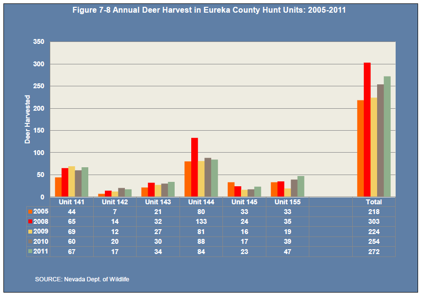
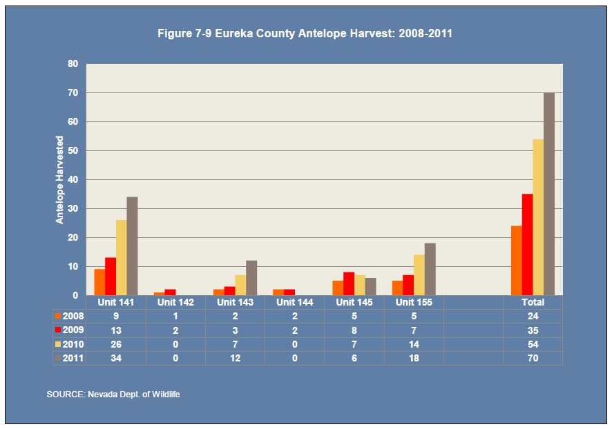
Figure 7-8 and Figure 7-9 provide data on annual mule deer and pronghorn antelope harvest in Eureka County hunt units. In recent years, deer and antelope populations in key Eureka County hunt areas have increased. NDOW also collect information on recreational fishing on various streams in the County.
Agriculture —
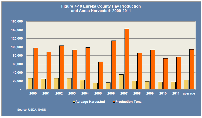
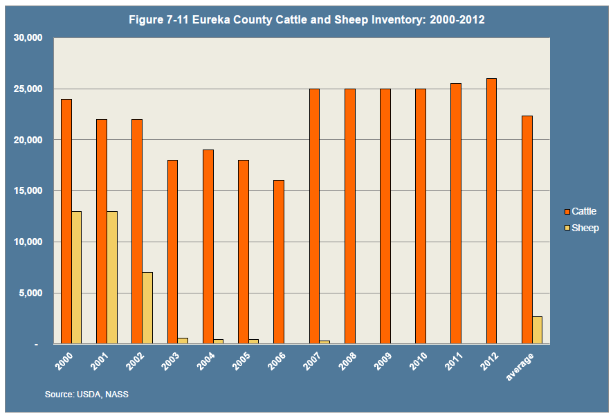
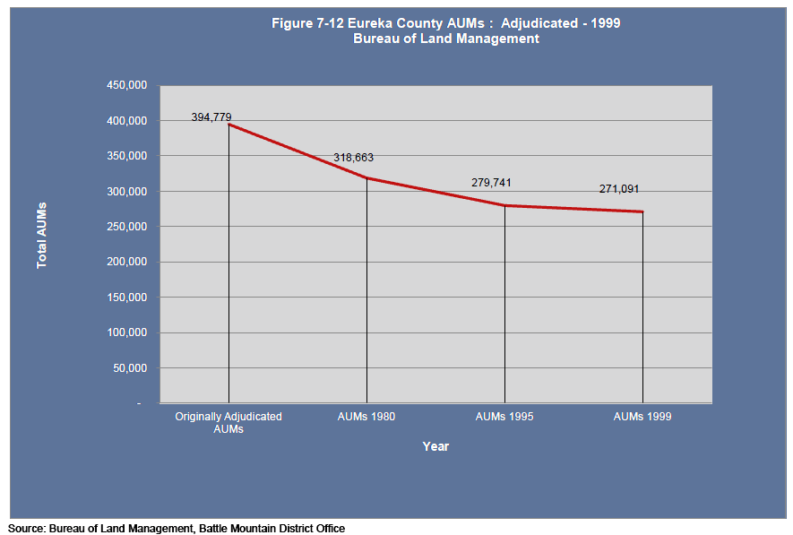
Figure 7-10 below shows Eureka County hay production and acreage harvested from 2000-2011. On average Eureka County produces between 80,000 and 100,000 tons of hay with an average of proximately 20,000 acres harvested. Figure 7-11 shows Eureka County cattle and calves inventory. The average inventory is approximately 22,000 head and has remained relatively stable over the last 5 years. Public land grazing supports cattle herds in Eureka County. Figure 7-12 shows the number of animal unit months permitted for grazing allotments in Eureka County. Total AUMs active continue in a downward trend.
References:
1. Nevada Agricultural Statistics, U.S. Department of Agriculture
http://www.nass.usda.gov/Statistics_by_State/Nevada/index.asp
2. Nevada Division of Water Resources
http://water.nv.gov/index.cfm
http://water.nv.gov/data/underground/
http://water.nv.gov/data/hydrographic/
3. US Geological Survey Streamflow Measurements Eureka County Streams, Sites 10245970, 10245960, 10322510, 10322535, 10322555
http://waterdata.usgs.gov/nv/nwis/nwisman/?site_no=10245970
http://waterdata.usgs.gov/nwis/nwisman/?site_no=10245960
http://waterdata.usgs.gov/nv/nwis/nwisman/?site_no=10322510
http://waterdata.usgs.gov/nwis/nwisman/?site_no=103225535
http://waterdata.usgs.gov/nv/nwis/nwisman/?site_no=10322555
4. Municipal Water Users for the Town of Eureka, Crescent Valley and Devils Gate GID, Eureka County Public Works, Ron Damele.
5. Bureau of Land Management, Animal Unit Months, Battle Mountain District Office.
|