
ACCIDENT DATA - continued
C WEATHER EFFECTS
Flooding in the upper Humboldt River basin seems to be a result of two different hydrological/climatological conditions. In the first, warm winter storms bring rain to an existing snowpack, resulting in rapid thaw and runoff. The floods of 1910 and 1962 were this kind of flood. The second kind are snowmelt floods, resulting from spring melting of greater-than-average snowpack. The floods of 1983 and 1984 were spring snowmelt floods.
 At least two of these flood events resulted in damage to the rail line and rail accidents. In the 1910 flood, both the intercontinental tracks in Palisade Canyon and the Eureka and Palisade Railroad from Palisade through Pine Valley were washed out. Contemporary photographs show water up to five feet deep inundating the town of Palisade, and a 30-mile-long lake filled Pine Valley. While the intercontinental railroads reopened soon after the flood, the Eureka and Palisade Railroad was closed for two years.
One of the most significant recent rail accidents in Eureka County took place in May 1984 (the $1.2 million Dunphy derailment described perviously). This accident was caused by high flood waters weakening bridge abutments and softening adjacent trackbed.
The June 9, 1980 derailment near Barth also possibly could have been a result of high water. June is one of the months of highest runoff in the Humboldt; the accident location was in Palisade Canyon, close to the river; 1980 was higher-than-average water year; and the accident was attributed to buckled or sunken tracks.
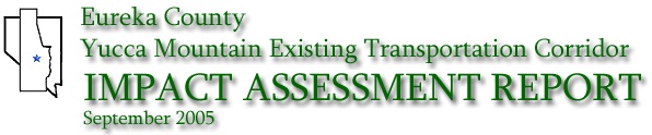
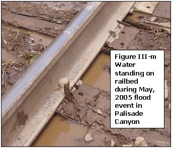
These photographs above were taken on May 18, 2005, during a high runoff period. Water can be seen in and around the track.
These might be similar conditions to those that contributed to the 1984 derailment, although the May, 2005 flood was not as large as the one in 1984.
During the May 18, 2005 high water event depicted in these photographs, the stream gauge height at the USGS Palisade Humboldt River gauge was just under 8.5 feet; during the May 1984 event the stream gauge stood at 10.08 feet.
Discharge in cubic feet per second (cfs) on May 18, 2005 was between 5000 and 6000 cfs , while on May 18, 1984, discharge was 7,870 cfs. Other pictures showing the flood event are in Appendix E.
During this 2005 flood event, Union Pacific apparently had to take special measures to protect tracks and equipment. Pictures in Appendix E show a section of Union Pacific track near Carlin where riprap and dirt has recently been placed to protect the track from the high water. Additionally, during this flood period, it was observed that all trains passing through Palisade Canyon were preceded by a pickup truck driving along the tracks, possibly to check for high water or water damage to the track. (Marshall, pers com).
While the May, 2005 event may not have been as large as the May, 1984 event, USGS data show that the Humboldt River was at or above flood stage for about 22 days in 2005, between about May 15 and June 5. These pictures, then, are a valuable record showing the condition of Union Pacific tracks during flood-stage flow in the Humboldt River in the Palisade Canyon area.
|